


10 Tage / 9 Nächte
ca. 130 km.
Sehr anspruchsvoll
4.630 m / 15.190 ft (Salkantay-Pass)
Cachora, Cusco
Aguas Calientes / Cusco
Camping und Hotel
2 bis 10 Personen
14 Jahre
April bis Oktober (Trockenzeit)
Die meisten Peru-Besucher besichtigen eine bedeutende Inka-Stätte. Diese Trekkingtour bietet Ihnen gleich zwei.
Choquequirao Es liegt auf 3.000 Metern Höhe auf einem Bergrücken über dem Apurímac-Canyon, ist allseitig von Bergen umgeben und nur zu Fuß erreichbar. Es gibt keine Straßen, keine Züge und keine Abkürzungen. Der einzige Zugang ist eine steile, zweitägige Wanderung vom Talboden aus, und der einzige Rückweg führt entweder auf demselben Weg zurück oder weiter zum... Salkantay Diese Schwierigkeit ist genau der Grund, warum Choquequirao nur einen Bruchteil der Besucher anzieht, die Machu Picchu Sie erhalten täglich neue Tickets. An den meisten Morgen steht Ihnen das gesamte Gelände für sich allein zur Verfügung.
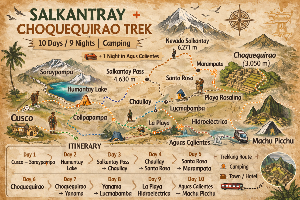
Die kombinierte Route beginnt in Choquequirao, durchquert den Apurímac-Canyon und die hohen Andenpässe, die die beiden Rundwege verbinden, trifft dann auf die Salkantay-Route und endet in Machu Picchu. Sie ist eine der die umfassendsten Trekking-Erlebnisse in Südamerika, Die Tour führte in zehn aufeinanderfolgenden Tagen durch tiefe Schluchten, abgelegene Inka-Stätten, Gletscherpässe, Nebelwälder und subtropischen Dschungel.
Diese Trekkingtour ist nicht für jedermann geeignet. Die Strecken sind lang, die Höhenunterschiede extrem, und es gibt Tage, an denen der Weg einem alles abverlangt. Doch wer sie bewältigt, kehrt mit etwas zurück, das sich kaum in Worte fassen lässt: Zwei antike Städte, die man ausschließlich zu Fuß erreicht, inmitten einer der spektakulärsten Berglandschaften der Welt .
Eine frühe Abfahrt von Cusco und eine dreistündige Fahrt bringen Sie nach Cachora, dem kleinen Dorf, das als Tor zu Choquequirao dient. Die Nachmittagswanderung ist im Vergleich zu dem, was noch kommt, nur ein Vorgeschmack: Sanft geht es hinab durch offenes Ackerland, und die ersten Ausblicke auf den Apurímac-Canyon eröffnen sich unter Ihnen. Das Lager wird in Capuliyoc aufgeschlagen, einem Aussichtspunkt mit Blick auf den Canyon. Es dauert einen Moment, bis man die gewaltigen Ausmaße des Anblicks erfasst hat.
Der Abstieg in den Apurímac-Canyon ist steil und anstrengend. Fast 1.500 Höhenmeter legt man im Laufe des Vormittags zurück, auf einem Pfad, der sich in Serpentinen durch Kakteen und trockenes Buschland hinab in einen der tiefsten Canyons der Welt schlängelt. Die Temperatur steigt mit dem Abstieg rapide an. Unten angekommen, fließt der Apurímac-Fluss reißend und türkisblau durch das Tal. Das Camp Playa Rosalina liegt direkt daneben. Nach dem Abstieg werden Ihre Beine die Anstrengung spüren.
Der Aufstieg aus der Schlucht ist der anstrengendste Teil der gesamten Trekkingtour. Man überwindet 1.500 Höhenmeter auf relativ kurzer Strecke, wobei der Pfad stetig durch immer üppigere Vegetation ansteigt, je höher man sich vom Schluchtboden erhebt. Choquequirao offenbart sich erst nach und nach, dann die Terrassen, dann die Zeremonialplattformen und schließlich die gesamte Anlage, die sich über den Bergrücken erstreckt. Das Lager wird neben den Ruinen aufgeschlagen. Am Nachmittag führt Sie Ihr Guide durch die Anlage, solange das Licht noch gut ist. Abends, wenn die anderen Besucher gegangen sind und die Schlucht zu beiden Seiten steil abfällt, wirkt der Ort völlig anders als alles, was Sie bisher gesehen haben.
Ein ganzer Vormittag steht Ihnen zur Verfügung, um die Stätte ausgiebig zu erkunden. Choquequirao erstreckt sich über ein deutlich größeres Gebiet, als die meisten Besucher erwarten, und viele der abgelegenen Terrassen und Plattformen sind nur zu Fuß erreichbar. Ihr Reiseleiter zeigt Ihnen Bereiche der Anlage, für die am vorherigen Nachmittag keine Zeit war, darunter die berühmten Lama-Terrassen mit ihren Steineinlegearbeiten – eine der ungewöhnlichsten Besonderheiten aller Inka-Stätten in Peru. Den Nachmittag können Sie in den Ruinen in Ihrem eigenen Tempo verbringen.
Die Route von Choquequirao führt weiter nach Norden durch abgelegenes Gebiet, das nur wenige Trekker je erreichen. Der Pfad überquert hohe Pässe oberhalb der Baumgrenze mit weiten Ausblicken auf die umliegenden Gebirgsketten, bevor er hinab in die Bauerngemeinde Maizal führt – ein Dorf mit wenigen Häusern und Terrassenfeldern, die seit Generationen dasselbe Land bewirtschaften. Das Camp hier fühlt sich wahrhaftig abgelegen an. Der Nachthimmel ist atemberaubend.
Eine lange Wanderung durch Nebelwald und Hochweiden verbindet den Choquequirao-Rundweg mit der Salkantay-Route. Der Pfad ist weniger begangen als die bisher begangenen Strecken, und die Vegetation ist dicht und abwechslungsreich. Am Nachmittag wird sich die Route für Kenner des Salkantay-Wanderwegs vertraut anfühlen, da sie den Flusstälern hinab in die tiefer gelegenen Gebiete des Santa-Teresa-Beckens folgt.
Der Aufstieg zurück in die Höhe beginnt. Der Pfad führt stetig bergauf vom Talboden durch wechselnde Vegetationszonen und trifft kurz vor Soraypampa wieder auf die klassische Salkantay-Route. Das Lager am Fuße des Salkantay-Gletschers liegt auf 3.900 Metern Höhe, und nach Sonnenuntergang sinkt die Temperatur rapide. Der Berg, auf den Sie zwei Tage lang zugewandert sind, liegt nun direkt über Ihnen. Morgen überqueren Sie ihn.
Die Überquerung des Salkantay-Passes auf 4.630 Metern Höhe ist der höchste Punkt der gesamten Route und einer ihrer Höhepunkte. Man bricht vor Sonnenaufgang in Kälte und Dunkelheit auf, erreicht den Pass im Morgengrauen und verbringt den Rest des Tages mit dem Abstieg durch eine Landschaft, die sich von Gletschergebiet zu subtropischem Dschungel komplett wandelt. Bei Santa Teresa angekommen, hat man die Höhe endgültig hinter sich gelassen. Die heißen Quellen erwarten einen – und die hat man sich redlich verdient.
Am letzten Morgen der eigentlichen Trekkingtour folgen Sie dem Urubamba-Fluss entlang der Eisenbahnlinie nach Aguas Calientes. Verglichen mit den vorangegangenen neun Tagen ist es eine gemütliche Wanderung, und Sie haben Zeit, alles Erlebte zu verarbeiten. Acht Tage lang haben Sie die unberührte Andenlandschaft, zwei antike Städte, einen Gletscherpass und eine Schlucht durchquert, die fast 3.000 Meter tief ins Tal abfällt. Aguas Calientes ist klein, lebhaft und komplett um den Berg herum gebaut, der sich darüber erhebt. Heute Abend übernachten Sie in einem richtigen Hotelzimmer. Das Abendessen ist nicht inbegriffen.
Der erste Bus zur Zitadelle fährt um 5:30 Uhr ab – seien Sie unbedingt dabei! Nach zehn Tagen Wanderung durch einige der entlegensten Gebiete der Anden fühlt sich die Ankunft in Machu Picchu wie ein wohlverdientes Erlebnis an, das den meisten Besuchern verwehrt bleibt. Ihr Reiseleiter führt Sie umfassend durch die Anlage und erklärt Ihnen die Geschichte, die Architektur und die Verbindung zwischen dieser Zitadelle und dem weitläufigen Inka-Netzwerk, durch das Sie die letzte Woche gewandert sind. Im Anschluss an die Führung haben Sie Zeit zur freien Verfügung, um die Anlage in Ihrem eigenen Tempo zu erkunden. Der Nachmittagszug zurück nach Cusco fährt durch das Heilige Tal und kommt am Abend an.

Lokales Trekkingunternehmen mit Sitz in Cusco, Spezialisierung in kleinen Gruppen, nachhaltig Salkantay- und Inka-Trail-Expeditionen.
Salkantay Horizons – Teil von My Peru Destinations Group © 2026 Alle Rechte vorbehalten
 Hallo My Peru Destinations Group, über Salkantay Horizons auf salkantay-trail.com, ich interessiere mich für einen Trek. Könnten Sie mir bitte mehr Informationen geben?